1891 Map of Weatherford
USGS Topo · Published 1891About this map
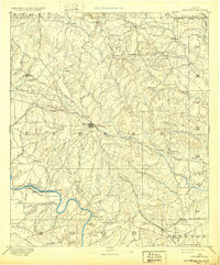
Weatherford serves as the central hub of this North Texas landscape, where the Texas and Pacific Railway branches out toward Lambert and Anneta. The terrain transitions from the broken hills of Skeen Peak and Indian Knob in the north to the fertile bottomlands of Big Valley along the southern bends of the Brazos River. This 1889 survey captures a network of rural post offices and early crossings that defined travel before modern bridges, including Stephensville Crossing and Powell Ferry.
Find a feature on this map
71 named features on this map. Tap any name to fly to it.
Don’t see what you’re looking for? This feature index may not catch every label — zoom into the map to look around manually.
Map Details
Editions of this 1891 Weatherford Map
This is the sole edition of this map. No revisions or reprints were ever made.
Historical Maps of Fort Worth Through Time
3 maps found