
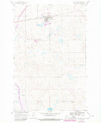
1959 Map of McClusky
USGS Topo · Published 1960About this map
Mc Clusky serves as the central hub of this Sheridan County landscape, situated along the Northern Pacific railroad line. The settlement pattern is defined by a traditional Midwestern grid, with Silbaugh Park providing a community space in the heart of town. Beyond the town limits, the terrain is characterized by a high concentration of prairie potholes and small water bodies, including Johns Lake and Pop Lake to the south. This 1959 survey reveals the decentralized education system of the era, marking rural schoolhouses that served the surrounding farmsteads. These include Whittaker Sch No 1 in the southeast, Johns Lake Sch No 2 near the lakefront, and School No 4 in the eastern section of the township. The map provides a precise record of these community landmarks and the local road network connecting the townships of Mc Clusky and Lamont.
Find a feature on this map
11 named features on this map. Tap any name to fly to it.
Don’t see what you’re looking for? This feature index may not catch every label — zoom into the map to look around manually.
Map Details
Editions of this 1959 McClusky Map
2 editions found
Other maps of this area

1945 · Pelican Lake
USGS Topo · 1:62,500

1947 · Pelican Lake
USGS Topo · 1:62,500

1947 · Lincoln Valley
USGS Topo · 1:62,500

1954 · McClusky
USGS Topo · 1:250,000

1958 · McClusky
USGS Topo · 1:250,000

1959 · Pickardville
USGS Topo · 1:24,000

1959 · Mercer SE
USGS Topo · 1:24,000

1960 · Lincoln Valley SE
USGS Topo · 1:24,000

1960 · Horse Lake
USGS Topo · 1:24,000

1960 · Florence Lake
USGS Topo · 1:24,000