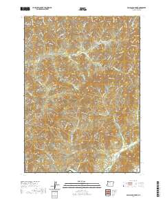
2020 Map of McCullough Creek
USGS Topo · Published 2020About this map
Silver Butte and the surrounding drainage basins of the Umpqua National Forest region characterize this 2020 landscape in Douglas County. The terrain is defined by a dense network of Bureau of Land Management logging roads, including the Cattle Ridge Mainline and The Fire Tower Rd, which weave through steep ridges and creek valleys. Notable high points like Grayback and Panther Butte overlook a complex system of waterways such as Middle Cr and McCullough Cr. For local historians and genealogists, the identification of family-named water sources like Bernstein Spring and Flory Spring provides specific points of interest in a region otherwise dominated by industrial timber management. The map's detailed contouring reveals the transition from deep valleys like Cedar Gulch to prominent peaks like Fir Point, reflecting the modern geospatial inventory of Oregon’s coastal range interior.
Find a feature on this map
75 named features on this map. Tap any name to fly to it.
Don’t see what you’re looking for? This feature index may not catch every label — zoom into the map to look around manually.
Map Details
Editions of this 2020 McCullough Creek Map
This is the sole edition of this map. No revisions or reprints were ever made.
Other maps of this area

1904 · Riddle
USGS Topo · 1:125,000

1946 · Galice
USGS Topo · 1:62,500

1946 · Dutchman Butte
USGS Topo · 1:62,500

1948 · Galice
USGS Topo · 1:62,500

1948 · Dutchman Butte
USGS Topo · 1:62,500

1954 · Glendale
USGS Topo · 1:62,500

1954 · Canyonville
USGS Topo · 1:62,500

1955 · Medford
USGS Topo · 1:250,000

1957 · Medford
USGS Topo · 1:250,000

1958 · Medford
USGS Topo · 1:250,000