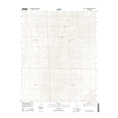
2014 Map of McCullough Mountain
USGS Topo · Published 2014About this map
McCullough Mtn and the broader McCullough Range dominate this high-elevation desert landscape in Southern Nevada. This 2014 survey captures the topographical intricacies of the Mojave Desert environment, where natural water sources were essential for early passage and survival. Vital desert seeps like Railroad Spring, McCullough Spring, and Pine Spring are precisely located amidst the steep contour lines, offering a glimpse into the natural resources that governed movement through this arid terrain. The mapping detail highlights the drainage patterns of the region, specifically Big Tiger Wash, which cuts through the southeastern portion of the quadrangle. As a modern digital-age record, this map provides an exacting look at the physical geography of Clark County, documenting the specific elevation data and coordinate systems that define the area's modern land management.
Find a feature on this map
11 named features on this map. Tap any name to fly to it.
Don’t see what you’re looking for? This feature index may not catch every label — zoom into the map to look around manually.
Map Details
Editions of this 2014 McCullough Mountain Map
This is the sole edition of this map. No revisions or reprints were ever made.
Other maps of this area

1910 · Ivanpah
USGS Topo · 1:250,000

1912 · Ivanpah
USGS Topo · 1:250,000

1942 · Ivanpah
USGS Topo · 1:250,000

1947 · Kingman
USGS Topo · 1:250,000

1948 · Kingman
USGS Topo · 1:250,000

1954 · Kingman
USGS Topo · 1:250,000

1955 · Kingman
USGS Topo · 1:250,000

1955 · Roach Lake
USGS Topo · 1:62,500

1956 · Ivanpah
USGS Topo · 1:62,500
1956 · Crescent Peak
USGS Topo · 1:62,500