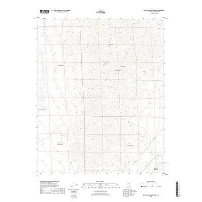
2018 Map of McCullough Mountain
USGS Topo · Published 2018About this map
The high desert landscape of the McCullough Range dominates this corner of the Mojave Desert south of Las Vegas. Centered on McCullough Mtn, the map reveals a rugged terrain where water is the most critical resource for history and survival. Small, vital water sources like Railroad Spring, McCullough Spring, and Pine Spring are scattered throughout the mountain slopes, marking the locations where early travelers and ranchers would have sought reprieve from the heat. In the southern portion of the quadrangle, the peaks of the Lucy Gray Mountains and the northern reach of the New York Mountains define the horizon. This 2018 survey also tracks the modern infrastructure bisecting the desert, including the prominent Powerline Rd and the drainage of Big Tiger Wash.
Find a feature on this map
14 named features on this map. Tap any name to fly to it.
Don’t see what you’re looking for? This feature index may not catch every label — zoom into the map to look around manually.
Map Details
Editions of this 2018 McCullough Mountain Map
This is the sole edition of this map. No revisions or reprints were ever made.
Other maps of this area

1910 · Ivanpah
USGS Topo · 1:250,000

1912 · Ivanpah
USGS Topo · 1:250,000

1942 · Ivanpah
USGS Topo · 1:250,000

1947 · Kingman
USGS Topo · 1:250,000

1948 · Kingman
USGS Topo · 1:250,000

1954 · Kingman
USGS Topo · 1:250,000

1955 · Kingman
USGS Topo · 1:250,000

1955 · Roach Lake
USGS Topo · 1:62,500

1956 · Ivanpah
USGS Topo · 1:62,500
1956 · Crescent Peak
USGS Topo · 1:62,500