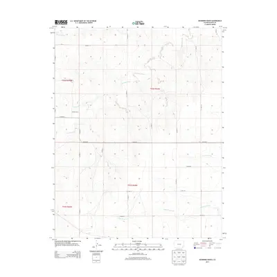
2013 Map of McEndree Ranch
USGS Topo · Published 2013About this map
McEndree Ranch and the small settlement of Maxey anchor this high plains landscape in the southeast corner of Colorado. The area is defined by a grid of rural county roads, such as CO Road RR and CO Road 12, which partition the wide drainage basins of Two Butte Creek and Maverick Creek. For those researching local lineages, the Maxey Cem serves as a vital touchstone for the families who settled this arid ranching country. The terrain is marked by seasonal watercourses like Snake Arroyo and the parallel flows of North Horse Creek and South Horse Creek. This map documents a quiet, enduring cattle-country lifestyle where the names on the land reflect the long-term stewardship of specific ranching operations and the remnants of early twentieth-century homesteading hubs.
Find a feature on this map
26 named features on this map. Tap any name to fly to it.
Don’t see what you’re looking for? This feature index may not catch every label — zoom into the map to look around manually.
Map Details
Editions of this 2013 McEndree Ranch Map
This is the sole edition of this map. No revisions or reprints were ever made.
Other maps of this area
1891 · Springfield
USGS Topo · 1:125,000
1892 · Two Butte
USGS Topo · 1:125,000
1893 · Two Butte
USGS Topo · 1:125,000
1893 · Springfield
USGS Topo · 1:125,000

1955 · La Junta
USGS Topo · 1:250,000

1958 · La Junta
USGS Topo · 1:250,000

1968 · La Junta
USGS Topo · 1:250,000
1971 · Big Rock Grange
USGS Topo · 1:24,000
1971 · Mc Endree Ranch
USGS Topo · 1:24,000
1971 · Deora
USGS Topo · 1:24,000