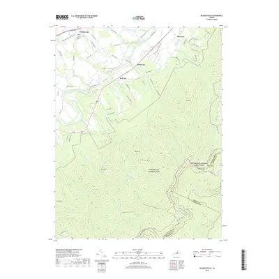
2019 Map of McGaheysville
USGS Topo · Published 2019About this map
Mcgaheysville serves as the gateway to the Blue Ridge mountains in this portion of the Page Valley. The landscape transitions from the fertile agricultural flats along the South Fork Shenandoah River to the protected wilderness of Shenandoah National Park. Local history is centered around settlements like Island Ford, Berrytown, and Rocky Bar, which developed along old routes like the Spotswood Trl. Genealogists may find interest in the Mount Olivet Cem near the town center. The map documents a rugged interior of hollows and ridges, including Eppert Hollow and Patterson Ridge, culminating at the crest of the mountains where the Appalachian National Scenic Trail winds through Pinefield Gap near Loft Mtn. Numerous mountain runs, such as Bearwallow Run and Deep Run, emphasize the complex drainage system feeding the Shenandoah watershed.
Find a feature on this map
77 named features on this map. Tap any name to fly to it.
Don’t see what you’re looking for? This feature index may not catch every label — zoom into the map to look around manually.
Map Details
Editions of this 2019 McGaheysville Map
This is the sole edition of this map. No revisions or reprints were ever made.
Other maps of this area

1892 · Harrisonburg
USGS Topo · 1:125,000

1931 · University
USGS Topo · 1:62,500

1934 · Waynesboro
USGS Topo · 1:48,000

1935 · University
USGS Topo · 1:62,500

1937 · Elkton
USGS Topo · 1:62,500

1939 · Waynesboro
USGS Topo · 1:62,500

1941 · Harrisonburg
USGS Topo · 1:62,500

1943 · Harrisonburg
USGS Topo · 1:62,500

1949 · Charlottesville
USGS Topo · 1:250,000

1956 · Charlottesville
USGS Topo · 1:250,000