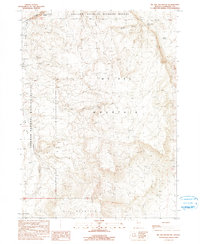
1990 Map of McGee Mountain
USGS Topo · Published 1990About this map
Sheldon National Wildlife Refuge encompasses this high desert landscape in Humboldt County, dominated by the massive landforms of McGee Mountain and Big Mountain. The terrain is defined by dramatic drainage systems, including the steep Thousand Creek Gorge to the north and the wide Virgin Valley to the west. This 1990 provisional survey records a territory where water management and mineral exploration were the primary human markers in an otherwise open expanse.
Find a feature on this map
18 named features on this map. Tap any name to fly to it.
Don’t see what you’re looking for? This feature index may not catch every label — zoom into the map to look around manually.
Map Details
Editions of this 1990 McGee Mountain Map
This is the sole edition of this map. No revisions or reprints were ever made.
Other maps of this area

1886 · Disaster
USGS Topo · 1:250,000

1889 · Long Valley
USGS Topo · 1:250,000

1893 · Disaster
USGS Topo · 1:250,000

1954 · Vya
USGS Topo · 1:250,000

1958 · Vya
USGS Topo · 1:250,000

1962 · Vya
USGS Topo · 1:250,000

1965 · Railroad Point
USGS Topo · 1:62,500

1965 · Idaho Canyon
USGS Topo · 1:62,500

1965 · Rock Spring Table
USGS Topo · 1:62,500

1966 · Big Spring Butte
USGS Topo · 1:62,500