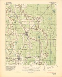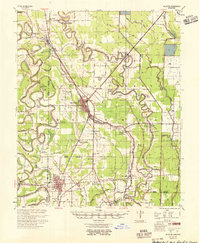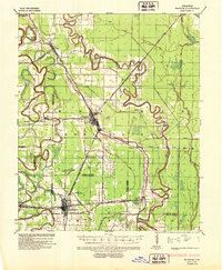
1937 Map of McGehee
USGS Topo · Published 1952About this map
McGehee and Dermott serve as the primary hubs in this delta landscape, which is defined by the winding paths of Bayou Macon and Bartholomew Bayou. This 1930s survey reveals a highly developed rail and utility infrastructure, with the Missouri Pacific railroad connecting small rural stations like Trippe Jc and Halley. An intricate network of gas lines, including the Memphis Natural Gas Pipe Line, cuts across the agricultural sections, reflecting the era's energy expansion through Desha and Chicot counties.
Find a feature on this map
45 named features on this map. Tap any name to fly to it.
Don’t see what you’re looking for? This feature index may not catch every label — zoom into the map to look around manually.
Map Details
Editions of this 1937 McGehee Map
This is the sole edition of this map. No revisions or reprints were ever made.