
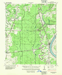
1936 Map of Lake Village
USGS Topo · Published 1949About this map
Lake Village sits along the massive crescent of Chicot Lake, serving as a focal point for this 1930s Mississippi River Delta landscape. The area is defined by an intricate network of waterways, including Bayou Bartholomew and the Boeuf River, which snake through the low-lying agricultural terrain. The Missouri Pacific railroad lines and early highways, such as U S Highway No 65, dictate the placement of small settlements like Montrose, Jerome, and Boydell. The map captures a moment before modern drainage and flood control significantly altered the Delta's character, showing numerous sloughs and bayous like Black Pond Slough and Boggy Bayou that once dominated the rural geography. This survey provides a look at the transition from river-dependent life to a rail-and-road economy in southeastern Arkansas.
Find a feature on this map
40 named features on this map. Tap any name to fly to it.
Don’t see what you’re looking for? This feature index may not catch every label — zoom into the map to look around manually.
Map Details
Editions of this 1936 Lake Village Map
2 editions found
Other maps of this area

1933 · Lamont
USGS Topo · 1:62,500

1935 · Mist
USGS Topo · 1:62,500

1935 · Wilmot
USGS Topo · 1:62,500

1935 · Cominto
USGS Topo · 1:62,500

1936 · McGehee
USGS Topo · 1:62,500

1936 · Eudora
USGS Topo · 1:62,500

1937 · McGehee
USGS Topo · 1:62,500

1939 · Readland
USGS Topo · 1:62,500

1939 · Refuge
USGS Topo · 1:62,500

1939 · Lamont
USGS Topo · 1:62,500