1936 Map of Eudora
USGS Topo · Published 1943About this map
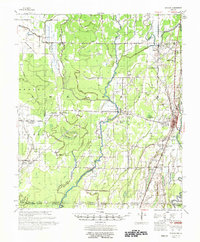
Eudora serves as the primary hub in this low-lying river country where the Missouri Pacific Railroad runs parallel to Macon Bayou. The landscape is defined by an intricate network of drainage and transport infrastructure, including the Standard Oil Pipe Line and numerous man-made channels like Canal No 2. These efforts to manage the wetlands are centered around natural features such as Hubbard Brake and the winding Boeuf River. Small rural communities and gathering places like Empire, Boueff, and Holly Grove Ch are scattered throughout the territory, linked by State Highway No 8. The presence of the Oil Pumping Station near the Arkansas and Louisiana border highlights the industrial activity supporting the region's economy during the mid-1930s.
Find a feature on this map
33 named features on this map. Tap any name to fly to it.
Don’t see what you’re looking for? This feature index may not catch every label — zoom into the map to look around manually.
Map Details
Editions of this 1936 Eudora Map
This is the sole edition of this map. No revisions or reprints were ever made.