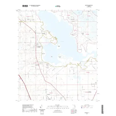
2021 Map of McIntosh
USGS Topo · Published 2021About this map
Orange Lake dominates the central landscape of this Florida interior region, serving as a focal point for several established communities along the Alachua and Marion county line. The settlement of McIntosh is situated on the lake's western shore, characterized by a structured grid of streets, while Boardman sits further north near the marshy edges. The map reveals a cluster of cultural and burial sites important for genealogical research, including Center Hill Cem, Center Point Cem, and the Millwood Cem further south near Millwood. The eastern portion of the lake is punctuated by landmarks such as Redbird Island and McCormick Island, with the village of Cross Creek positioned near the channel connecting to Little Lochloosa Lake. Transportation is defined by the corridor of US Highway 441 passing through Orange Lake (settlement) and Irvine, while small-scale aviation is represented by Rimes Lakecrest Airport.
Find a feature on this map
74 named features on this map. Tap any name to fly to it.
Don’t see what you’re looking for? This feature index may not catch every label — zoom into the map to look around manually.
Map Details
Editions of this 2021 McIntosh Map
This is the sole edition of this map. No revisions or reprints were ever made.
Other maps of this area

1890 · Arredondo
USGS Topo · 1:62,500

1892 · Arredondo
USGS Topo · 1:62,500

1893 · Citra
USGS Topo · 1:62,500

1894 · Arredondo
USGS Topo · 1:62,500

1895 · Williston
USGS Topo · 1:62,500

1895 · Citra
USGS Topo · 1:62,500

1938 · Hawthorn
USGS Topo · 1:48,000

1943 · Hawthorn
USGS Topo · 1:62,500

1954 · Gainesville
USGS Topo · 1:250,000

1958 · Gainesville
USGS Topo · 1:250,000