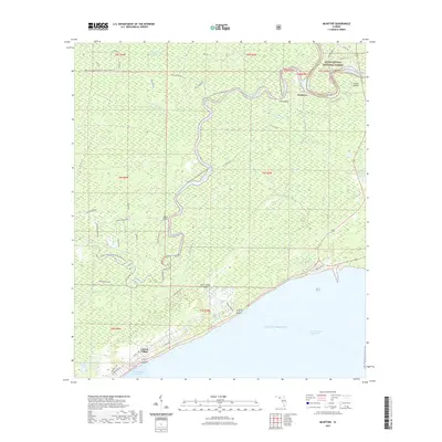
2021 Map of McIntyre
USGS Topo · Published 2021About this map
Saint James Island is defined by its position between the winding Crooked River and the open waters of the Gulf of Mexico. This coastal landscape in Franklin County is a complex network of tidal waterways and forested tracts, where the Ochlockonee River flows south past Lewis Bluff to meet the Intracoastal Waterway. The settlement of Lanark Village sits directly on the coast, overlooking Saint George Sound, while the interior remains dominated by the southern reaches of the Apalachicola National Forest. Small bluffs and landings, such as Davis Bluff and Clark's Landing, suggest a historical reliance on these river systems for transit and access. The map details numerous forest roads and trails, including the Florida Circumnavigational Paddling Trail, which highlights the contemporary recreational use of the Womack Creek Swamp and Brandy Creek drainages.
Find a feature on this map
52 named features on this map. Tap any name to fly to it.
Don’t see what you’re looking for? This feature index may not catch every label — zoom into the map to look around manually.
Map Details
Editions of this 2021 McIntyre Map
This is the sole edition of this map. No revisions or reprints were ever made.
Other maps of this area

1940 · Arran
USGS Topo · 1:62,500

1943 · Arran
USGS Topo · 1:62,500

1943 · Dog Island
USGS Topo · 1:31,680

1943 · Carrabelle
USGS Topo · 1:24,000

1943 · St. Teresa Beach
USGS Topo · 1:24,000

1944 · Pickett Bay
USGS Topo · 1:31,680

1944 · Carrabelle
USGS Topo · 1:31,680

1945 · Thousand Yard Bay
USGS Topo · 1:31,680

1945 · Mc Intyre
USGS Topo · 1:31,680

1945 · St Teresa
USGS Topo · 1:31,680