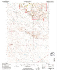
1993 Map of McKenzie Butte
USGS Topo · Published 1996About this map
South Cave Hills rise prominently in the northern reaches of this landscape, deeply integrated with the Custer National Forest. The map documents a rugged rangeland economy where established homesteads like Butler Ranch and R Johnson Ranch sit along seasonal watercourses. The presence of the Hilton Mine and several survey markers, including an Oil Well and Drill Hole, point to the extractive industries that have long operated alongside cattle grazing in this corner of the state. Narrow canyons such as Holdup Canyon and Timber Canyon cut through the high ground, while prominent landmarks like McKenzie Butte and Thumb Butte provide navigational anchors for the sparse network of dirt tracks including the Cave Hills Road. Numerous named water sources, such as John Brown Spring No 2 and McKenzie Spring, underscore the vital importance of dependable water in this arid environment.
Find a feature on this map
33 named features on this map. Tap any name to fly to it.
Don’t see what you’re looking for? This feature index may not catch every label — zoom into the map to look around manually.
Map Details
Editions of this 1993 McKenzie Butte Map
This is the sole edition of this map. No revisions or reprints were ever made.
Other maps of this area

1935 · Reva
USGS Topo · 1:125,000

1935 · Buffalo
USGS Topo · 1:125,000

1954 · Lemmon
USGS Topo · 1:250,000

1957 · Lemmon
USGS Topo · 1:250,000

1968 · Ludlow
USGS Topo · 1:24,000

1969 · Ladner
USGS Topo · 1:24,000

1969 · Ladner SE
USGS Topo · 1:24,000

1971 · Buffalo
USGS Topo · 1:24,000
1971 · Lahti Butte
USGS Topo · 1:24,000

1971 · McKenzie Butte
USGS Topo · 1:24,000