
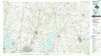
1985 Map of McKinney
USGS Topo · Published 1985About this map
The East Fork Trinity River and its numerous tributaries, including Sister Grove Creek and Arnold Creek, define the drainage patterns of this North Texas landscape during the mid-1980s. This survey records a transition period for rural communities and smaller towns such as Westminster, Valdasta, and Blue Ridge. The geography is heavily influenced by a dense network of transit and industry, featuring multiple rail lines like the Southern Pacific RR and St Louis Southwestern RR, alongside several Gravel Pits and a Quarry indicating active local resource extraction. Prominent aviation landmarks such as the Caddo Mills Municipal Airport and Majors Airport serve as major navigational points. Smaller settlements like Frognot and Pilot Grove are documented alongside local landmarks such as Henslee Chapel, providing a detailed look at the region's development before the rapid expansion of the Dallas-Fort Worth metroplex changed these outlying areas.
Find a feature on this map
170 named features on this map. Tap any name to fly to it.
Don’t see what you’re looking for? This feature index may not catch every label — zoom into the map to look around manually.
Map Details
Editions of this 1985 McKinney Map
2 editions found
Other maps of this area

1891 · Dallas
USGS Topo · 1:125,000

1893 · Dallas
USGS Topo · 1:125,000

1894 · Fort Worth
USGS Topo · 1:125,000

1901 · Denison
USGS Topo · 1:125,000

1902 · Gainesville
USGS Topo · 1:125,000

1903 · Paris
USGS Topo · 1:125,000
1912 · Rockwall
USGS Topo · 1:31,680

1919 · Royse City
USGS Topo · 1:62,500

1924 · Farmersville 3-c
USGS Topo · 1:48,000

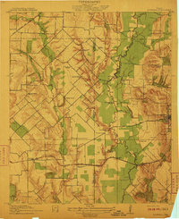
1924 · Mc Kinney 4-d
USGS Topo · 1:48,000