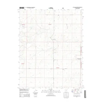
2013 Map of McLaughlin Bridge
USGS Topo · Published 2013About this map
Corrumpa Cr and its tributaries carve a network of drainage channels across this portion of Union County, reflecting the arid but dynamic hydrology of the High Plains. This 2013 survey illustrates a landscape of large-scale land management and livestock infrastructure, marked by the eastern reaches of the Kiowa National Grassland. Human presence is defined by a sparse grid of section-line roads such as Campbell Rd and Lake Rd, connecting remote points of interest. The locality of McLaughlin and the nearby McLaughlin Bridge serve as primary landmarks for navigating the watershed. Local history and genealogy interests are centered at Grandview Cem, while the Rohrer Windmill stands as a functional artifact of the ranching economy that has long sustained this corner of New Mexico.
Find a feature on this map
21 named features on this map. Tap any name to fly to it.
Don’t see what you’re looking for? This feature index may not catch every label — zoom into the map to look around manually.
Map Details
Editions of this 2013 McLaughlin Bridge Map
This is the sole edition of this map. No revisions or reprints were ever made.
Other maps of this area
1954 · Dalhart
USGS Topo · 1:250,000
1958 · Dalhart
USGS Topo · 1:250,000
1962 · Dalhart
USGS Topo · 1:250,000
1972 · Seneca
USGS Topo · 1:24,000
1972 · Mc Laughlin Bridge
USGS Topo · 1:24,000
1972 · Mount Dora
USGS Topo · 1:24,000
1972 · Bible Top Butte
USGS Topo · 1:24,000
1972 · Guy
USGS Topo · 1:24,000
1972 · Cuates School
USGS Topo · 1:24,000
1972 · Atencio
USGS Topo · 1:24,000