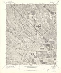
1971 Map of McMicken Dam
USGS Topo · Published 1972About this map
The community of Beardsley sits at the edge of a rapidly changing landscape in the early 1970s, where agricultural grid patterns meet the desert floor. This orthophotoquad, created from aerial photographs, provides a rare visual record of the massive hydraulic infrastructure required to support Maricopa County’s expansion. Dominating the central terrain is the Mc Micken Dam, part of a sophisticated water management system that includes the Trilby Wash Detention Basin and the long, linear stretch of the Beardsley Canal. To the northeast, the land rises toward Bunker Peak, while the lower elevations are carved by natural drainage channels. The map captures a moment when large-scale irrigation and flood control systems were actively reshaping the arid environment for cultivation and settlement.
Find a feature on this map
5 named features on this map. Tap any name to fly to it.
Don’t see what you’re looking for? This feature index may not catch every label — zoom into the map to look around manually.
Map Details
Editions of this 1971 McMicken Dam Map
This is the sole edition of this map. No revisions or reprints were ever made.
Other maps of this area

1954 · Phoenix
USGS Topo · 1:250,000

1957 · Phoenix
USGS Topo · 1:250,000

1957 · White Tank Mts. SE
USGS Topo · 1:24,000

1957 · White Tank Mts. NE
USGS Topo · 1:24,000

1957 · Calderwood Butte
USGS Topo · 1:24,000

1957 · McMicken Dam
USGS Topo · 1:24,000

1957 · El Mirage
USGS Topo · 1:24,000

1957 · Waddell
USGS Topo · 1:24,000

1957 · White Tank Mts.
USGS Topo · 1:62,500

1958 · Phoenix
USGS Topo · 1:250,000