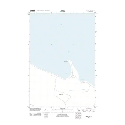
2011 Map of McRae Bay
USGS Topo · Published 2011About this map
Bois Blanc Island is defined by its isolation in the waters of Lake Huron, where the northeastern shoreline is detailed in this 2011 survey. The landscape is dotted with several inland water bodies, including Deer Lake, Lost Lake, and Lake Mary, suggesting a terrain of low-lying basins and varied hydrology. Maritime history is anchored by Lighthouse Point and the Bois Blanc Light, which mark the entry to McRae Bay. Inland, the map reveals a network of local roads such as Lighthouse Ln and Central Dr that connect the coastal points to the interior. The presence of McRae Cemetery provides a tangible link to the island's historical settlement, offering genealogists a specific coordinate for early island families amidst the surrounding Swedes Bay coastline.
Find a feature on this map
18 named features on this map. Tap any name to fly to it.
Don’t see what you’re looking for? This feature index may not catch every label — zoom into the map to look around manually.
Map Details
Editions of this 2011 McRae Bay Map
This is the sole edition of this map. No revisions or reprints were ever made.
Other maps of this area

1932 · St Ignace NE
USGS Topo · 1:31,680

1955 · Cheboygan
USGS Topo · 1:250,000

1957 · Cheboygan
USGS Topo · 1:62,500

1957 · Mullett Lake
USGS Topo · 1:62,500

1958 · Cheboygan
USGS Topo · 1:250,000

1964 · Round Island
USGS Topo · 1:24,000
1964 · Goose Island
USGS Topo · 1:24,000
1964 · St. Martin Island
USGS Topo · 1:24,000

1964 · McRae Bay
USGS Topo · 1:24,000
1964 · Cedarville
USGS Topo · 1:24,000