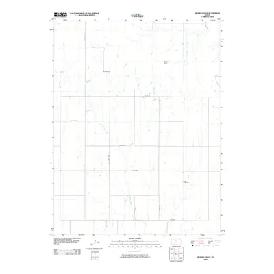
2009 Map of Meades Ranch
USGS Topo · Published 2009About this map
Meades Ranch serves as the focal point of this Osborne County landscape, a location of immense geodesy significance as it was historically the geodetic center of North America. This survey captures the rural character of the region where the East Fork Wolf Creek carves its way through the terrain, dictating the placement of crossing roads such as W 280th Dr and W 300th Dr. The grid of section lines is maintained by a network of local routes including S 70th Ave and Co Rd 412. Cultural markers like Delhi Cemetery provide essential touchpoints for genealogical research, anchoring family histories to this specific stretch of Kansas. The sparse distribution of buildings and the dominance of natural drainage patterns highlight the enduring agricultural lifestyle of the area.
Find a feature on this map
17 named features on this map. Tap any name to fly to it.
Don’t see what you’re looking for? This feature index may not catch every label — zoom into the map to look around manually.
Map Details
Editions of this 2009 Meades Ranch Map
This is the sole edition of this map. No revisions or reprints were ever made.
Other maps of this area

1894 · Beloit
USGS Topo · 1:125,000

1896 · Osborne
USGS Topo · 1:125,000

1955 · Beloit
USGS Topo · 1:250,000

1959 · Beloit
USGS Topo · 1:250,000

1963 · Sylvan Grove
USGS Topo · 1:24,000

1967 · Hunter
USGS Topo · 1:24,000

1978 · Osborne SW
USGS Topo · 1:24,000
1978 · Tipton
USGS Topo · 1:24,000
1978 · Lucas
USGS Topo · 1:24,000
1978 · Luray
USGS Topo · 1:24,000