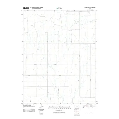
2012 Map of Meades Ranch
USGS Topo · Published 2012About this map
Meades Ranch serves as a primary geographic anchor for this rural portion of Osborne County, Kansas. The landscape is defined by the winding drainages of the E Fork Wolf Cr and the N Br Spillman Cr, which carve through the high plains terrain. A sparse network of section-line roads, including Co RD-412 and N Co Line Rd, structures the agricultural layout of the region. Local history and genealogy researchers will find the Delhi Cem located in the southeastern quadrant, a silent marker of the early community that once centered around the nearby drainage basins. Lake Hobbie provides a rare contained water feature in this otherwise arid expanse of ranching and farm land.
Find a feature on this map
26 named features on this map. Tap any name to fly to it.
Don’t see what you’re looking for? This feature index may not catch every label — zoom into the map to look around manually.
Map Details
Editions of this 2012 Meades Ranch Map
This is the sole edition of this map. No revisions or reprints were ever made.
Other maps of this area

1894 · Beloit
USGS Topo · 1:125,000

1896 · Osborne
USGS Topo · 1:125,000

1955 · Beloit
USGS Topo · 1:250,000

1959 · Beloit
USGS Topo · 1:250,000

1963 · Sylvan Grove
USGS Topo · 1:24,000

1967 · Hunter
USGS Topo · 1:24,000

1978 · Osborne SW
USGS Topo · 1:24,000
1978 · Tipton
USGS Topo · 1:24,000
1978 · Lucas
USGS Topo · 1:24,000
1978 · Luray
USGS Topo · 1:24,000