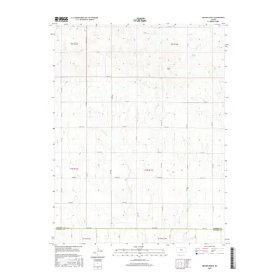
2015 Map of Meades Ranch
USGS Topo · Published 2015About this map
Meades Ranch sits at the heart of this North Central Kansas landscape, an area characterized by the dissected uplands typical of the region. The map reveals a meticulous grid of township and range lines, including t9s r11w and t10s r11w, which dictate the placement of local thoroughfares like Co Rd 691 and S 40th Ave. Water features are scarce but significant in this environment, with the small Lake Hobbie and the meandering E Fork Wolf Cr providing vital drainage. For genealogists and local historians, the Delhi Cem located along the eastern edge provides a specific point of interest. The southern boundary of the map captures the transition into Russell Co along Co Rd 420, illustrating the connectivity between rural agricultural sectors through roads like Peterson Rd.
Find a feature on this map
33 named features on this map. Tap any name to fly to it.
Don’t see what you’re looking for? This feature index may not catch every label — zoom into the map to look around manually.
Map Details
Editions of this 2015 Meades Ranch Map
This is the sole edition of this map. No revisions or reprints were ever made.
Other maps of this area

1894 · Beloit
USGS Topo · 1:125,000

1896 · Osborne
USGS Topo · 1:125,000

1955 · Beloit
USGS Topo · 1:250,000

1959 · Beloit
USGS Topo · 1:250,000

1963 · Sylvan Grove
USGS Topo · 1:24,000

1967 · Hunter
USGS Topo · 1:24,000

1978 · Osborne SW
USGS Topo · 1:24,000
1978 · Tipton
USGS Topo · 1:24,000
1978 · Lucas
USGS Topo · 1:24,000
1978 · Luray
USGS Topo · 1:24,000