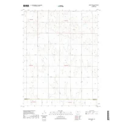
2018 Map of Meades Ranch
USGS Topo · Published 2018About this map
Meades Ranch sits at the heart of this central Kansas landscape, a location of significant geodetic importance where the rolling prairie meets the headwaters of the E Fork Wolf Cr. The 2018 survey reveals a sparsely populated agricultural region defined by a precise section-line road grid, including S 60th Ave and W 260th Dr. Local history and genealogy are preserved at the Delhi Cem in the southeastern portion of the quadrangle. Small-scale water management is evident at Lake Hobbie, while the southern boundary follows the straight line between Osborne Co and Russell Co. The map illustrates a modern era of land use that remains deeply rooted in the original township and range system, visible through labels like t9s r11w.
Find a feature on this map
33 named features on this map. Tap any name to fly to it.
Don’t see what you’re looking for? This feature index may not catch every label — zoom into the map to look around manually.
Map Details
Editions of this 2018 Meades Ranch Map
This is the sole edition of this map. No revisions or reprints were ever made.
Other maps of this area

1894 · Beloit
USGS Topo · 1:125,000

1896 · Osborne
USGS Topo · 1:125,000

1955 · Beloit
USGS Topo · 1:250,000

1959 · Beloit
USGS Topo · 1:250,000

1963 · Sylvan Grove
USGS Topo · 1:24,000

1967 · Hunter
USGS Topo · 1:24,000

1978 · Osborne SW
USGS Topo · 1:24,000
1978 · Tipton
USGS Topo · 1:24,000
1978 · Lucas
USGS Topo · 1:24,000
1978 · Luray
USGS Topo · 1:24,000