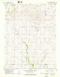
1978 Map of Meades Ranch
USGS Topo · Published 1979About this map
Meades Ranch serves as the primary focal point of this North Central Kansas survey, notable for its designation as a Geodetic Base Point. This location represents a fundamental datum for surveying across North America, situated where the townships of Jackson, Delhi, and Winfield meet. The landscape is defined by the winding course of the East Fork Wolf Creek, which drains toward the southern boundary near the line between Osborne Co and Russell Co. Local history is anchored by the Delhi Cem and smaller water features like Lake Hobbie. The mapping of townships such as Luray and Fairview reflects the agricultural grid system of the late 1970s, intersected by a prominent Pipeline that cuts across the rural landscape, illustrating the infrastructure of the era.
Find a feature on this map
11 named features on this map. Tap any name to fly to it.
Don’t see what you’re looking for? This feature index may not catch every label — zoom into the map to look around manually.
Map Details
Editions of this 1978 Meades Ranch Map
This is the sole edition of this map. No revisions or reprints were ever made.
Other maps of this area

1894 · Beloit
USGS Topo · 1:125,000

1896 · Osborne
USGS Topo · 1:125,000

1955 · Beloit
USGS Topo · 1:250,000

1959 · Beloit
USGS Topo · 1:250,000

1963 · Sylvan Grove
USGS Topo · 1:24,000

1967 · Hunter
USGS Topo · 1:24,000

1978 · Osborne SW
USGS Topo · 1:24,000
1978 · Tipton
USGS Topo · 1:24,000
1978 · Lucas
USGS Topo · 1:24,000
1978 · Luray
USGS Topo · 1:24,000