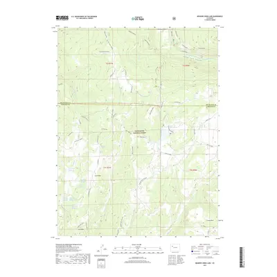
2019 Map of Meadow Creek Lake
USGS Topo · Published 2019About this map
White River National Forest encompasses the high-altitude landscape of this 2019 survey, where the border between Rio Blanco and Garfield counties bisects a network of ridges and river canyons. The drainage of the South Fork White River carves through South Fork Canyon in the north, while the southern terrain is defined by the prominent Clark Ridge and Clinetop Mesa. This area is characterized by its hydrological density, featuring a series of named water sources including Clark Cabin Spring and a numbered sequence of six springs along Clark Ridge.
Find a feature on this map
53 named features on this map. Tap any name to fly to it.
Don’t see what you’re looking for? This feature index may not catch every label — zoom into the map to look around manually.
Map Details
Editions of this 2019 Meadow Creek Lake Map
This is the sole edition of this map. No revisions or reprints were ever made.
Other maps of this area

1906 · Grand Hogback
USGS Topo · 1:125,000

1910 · Grand Hogback
USGS Topo · 1:125,000

1927 · Glenwood Springs
USGS Topo · 1:125,000

1930 · Glenwood Springs
USGS Topo · 1:125,000

1957 · Leadville
USGS Topo · 1:250,000

1959 · Leadville
USGS Topo · 1:250,000

1960 · Leadville
USGS Topo · 1:250,000

1962 · Leadville
USGS Topo · 1:250,000

1964 · Leadville
USGS Topo · 1:250,000
1966 · Rifle Falls
USGS Topo · 1:24,000