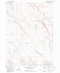
1980 Map of Meadow Lake
USGS Topo · Published 1980About this map
Robinson Valley and the surrounding high desert of Harney County are defined by a network of seasonal water sources and named landmarks that supported the region's livestock heritage. In this 1980 survey, the landscape is punctuated by numerous catchments and natural pools, including Moon Lake, Deep Lake, and Green Lake. The presence of Deadmans Bedground in the southern portion of the quadrangle alludes to the historical movement of cattle or sheep through these open ranges, where water was the primary concern for survival.
Find a feature on this map
18 named features on this map. Tap any name to fly to it.
Don’t see what you’re looking for? This feature index may not catch every label — zoom into the map to look around manually.
Map Details
Editions of this 1980 Meadow Lake Map
This is the sole edition of this map. No revisions or reprints were ever made.
Other maps of this area

1955 · Burns
USGS Topo · 1:250,000

1955 · Adel
USGS Topo · 1:250,000

1957 · Adel
USGS Topo · 1:250,000

1958 · Burns
USGS Topo · 1:250,000

1958 · Adel
USGS Topo · 1:250,000

1959 · Burns
USGS Topo · 1:250,000

1962 · Adel
USGS Topo · 1:250,000

1971 · Clover Swale
USGS Topo · 1:24,000
1971 · Keg Sprs Valley West
USGS Topo · 1:24,000
1971 · Balls Lake
USGS Topo · 1:24,000