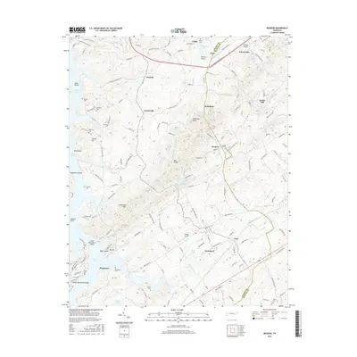
2016 Map of Meadow
USGS Topo · Published 2016About this map
Greenback and Friendsville anchor this 2016 survey along the complex border of Loudon and Blount Counties. The landscape is defined by the winding reaches of Tellico Lake and the northern presence of Fort Loudoun Lake, reflecting the transformative impact of mid-century water projects on the Tennessee River valley. Genealogists will find a high density of small family and community burial grounds, including the Unitia Cem, McDonald Cem, and Morganton Cem, which often represent the final vestiges of older riverside settlements. The area shows a transition from traditional rural patterns to modern infrastructure, represented by the Village Airport and residential developments like those near Lotterdale Knob. Numerous named hollows and knobs, such as Negro Hollow and Alexander Knob, provide a detailed view of the localized topography that shaped the early road networks and farming boundaries of the region.
Find a feature on this map
154 named features on this map. Tap any name to fly to it.
Don’t see what you’re looking for? This feature index may not catch every label — zoom into the map to look around manually.
Map Details
Editions of this 2016 Meadow Map
This is the sole edition of this map. No revisions or reprints were ever made.
Other maps of this area

1895 · Loudon
USGS Topo · 1:125,000

1935 · Binfield
USGS Topo · 1:24,000

1935 · Meadow
USGS Topo · 1:24,000

1935 · Lenoir City
USGS Topo · 1:24,000
1935 · Tallassee
USGS Topo · 1:24,000
1935 · Vonore
USGS Topo · 1:24,000
1936 · Madisonville
USGS Topo · 1:24,000

1936 · Louisville
USGS Topo · 1:24,000

1936 · Friendship
USGS Topo · 1:48,000

1936 · Loudon
USGS Topo · 1:24,000