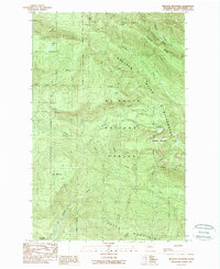
1989 Map of Meadow Mountain
USGS Topo · Published 1989About this map
Boulder River carves through the heart of this landscape, separating the high elevations of Boulder Ridge and Wheeler Mountain from the southern peaks of Olo Mountain and Green Mountain. The 1980s terrain is characterized by the established boundaries of the Mt Baker-Snoqualmie National Forest and the Boulder River Wilderness, highlighting a period of conservation and land management in the Cascade Range.
Find a feature on this map
31 named features on this map. Tap any name to fly to it.
Don’t see what you’re looking for? This feature index may not catch every label — zoom into the map to look around manually.
Map Details
Editions of this 1989 Meadow Mountain Map
This is the sole edition of this map. No revisions or reprints were ever made.
Other maps of this area

1899 · Stillaguamish
USGS Topo · 1:125,000

1901 · Stilaguamish
USGS Topo · 1:125,000

1955 · Concrete
USGS Topo · 1:250,000

1956 · Oso
USGS Topo · 1:62,500

1956 · Granite Falls
USGS Topo · 1:62,500

1957 · Silverton
USGS Topo · 1:62,500

1958 · Concrete
USGS Topo · 1:250,000

1962 · Concrete
USGS Topo · 1:250,000
1966 · Fortson
USGS Topo · 1:24,000
1989 · Whitehorse Mtn.
USGS Topo · 1:24,000