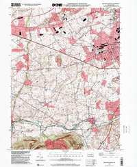
1999 Map of Mechanicsburg
USGS Topo · Published 2001About this map
The Mechanicsburg Naval Supply Center anchors the northeastern corner of this 1999 landscape, a significant military logistical hub that shapes the layout of Mechanicsburg. To the south, the terrain descends toward the winding Yellow Breeches Creek, where the leisure grounds of Williams Grove Park and the settlement of Williams Grove are located. This survey captures a moment when the rural character of Cumberland County was increasingly intersected by major transportation corridors, including the Pennsylvania Turnpike and Harrisburg Pike, yet many 19th-century anchors remained.
Find a feature on this map
56 named features on this map. Tap any name to fly to it.
Don’t see what you’re looking for? This feature index may not catch every label — zoom into the map to look around manually.
Map Details
Editions of this 1999 Mechanicsburg Map
This is the sole edition of this map. No revisions or reprints were ever made.
Other maps of this area

1892 · Harrisburg
USGS Topo · 1:62,500

1899 · Harrisburg
USGS Topo · 1:62,500

1904 · Carlisle
USGS Topo · 1:62,500

1906 · New Cumberland
USGS Topo · 1:62,500

1907 · New Bloomfield
USGS Topo · 1:62,500

1924 · Harrisburg
USGS Topo · 1:62,500

1943 · New Cumberland
USGS Topo · 1:62,500

1943 · Harrisburg
USGS Topo · 1:62,500

1943 · New Bloomfield
USGS Topo · 1:62,500

1943 · Carlisle
USGS Topo · 1:62,500
Featured Places
- Middlesex Township, PA
- New Kingstown, Silver Spring Township
- Rosegarden, PA
- Mechanicsburg, PA
- Locust Point, Monroe Township