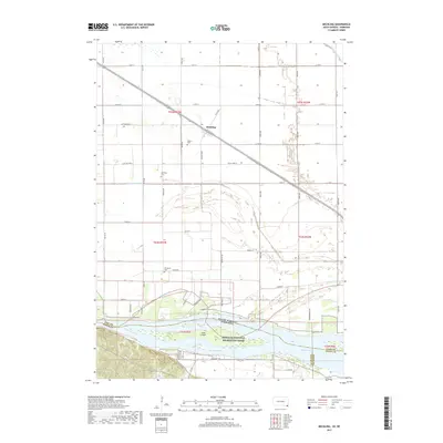
2017 Map of Meckling
USGS Topo · Published 2017About this map
Meckling serves as the central hub of this agricultural landscape in Clay County, situated along a prominent rail line that cuts diagonally through the township. The map details a strictly organized grid of rural roads, including Meckling Rd and Cottonwood St, which connect various farmsteads and historic family burial sites such as Taylor Cem, Meckling Cem, and Evergreen Cem. The southern portion of the sheet is dominated by the wide expanse of the Missouri River, which forms the state boundary with Nebraska. This riverine environment includes Goat Island and is preserved as part of the Missouri National Recreation River. The hydrology of the northern flats is defined by managed drainage systems like the Clay Creek Ditch and Yankton Clay Ditch, illustrating the long-standing efforts to reclaim and manage the fertile bottomlands for production.
Find a feature on this map
45 named features on this map. Tap any name to fly to it.
Don’t see what you’re looking for? This feature index may not catch every label — zoom into the map to look around manually.
Map Details
Editions of this 2017 Meckling Map
This is the sole edition of this map. No revisions or reprints were ever made.
Other maps of this area

1898 · Elk Point
USGS Topo · 1:125,000

1901 · Elk Point
USGS Topo · 1:125,000

1907 · Elk Point
USGS Topo · 1:125,000

1955 · Sioux City
USGS Topo · 1:250,000

1957 · Gayville
USGS Topo · 1:24,000

1958 · Sioux City
USGS Topo · 1:250,000

1959 · Sioux City
USGS Topo · 1:250,000

1964 · Maskell
USGS Topo · 1:24,000

1968 · Obert
USGS Topo · 1:24,000

1968 · St. Helena
USGS Topo · 1:24,000