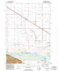
1994 Map of Meckling
USGS Topo · Published 1995About this map
Meckling serves as the focal point of this mid-1990s survey, situated within a landscape shaped by the shifting course of the Missouri River. To the north, the prominent rise of Spirit Mound breaks the agricultural grid, while the southern reaches of the map are defined by the Clay and Cedar County line as it follows the river's path. The region is notable for its preserved island terrain, specifically Goat Island, which sits between the South Dakota and Nebraska boundary. Local heritage is well-documented through several rural burial grounds including Taylor Cem, Meckling Cem, and Evergreen Cem. The map reveals a land management pattern focused on both production and recreation, from the State Game Production Area to the developed Clay State Recreation Area and Clay County Park near the riverbanks.
Find a feature on this map
19 named features on this map. Tap any name to fly to it.
Don’t see what you’re looking for? This feature index may not catch every label — zoom into the map to look around manually.
Map Details
Editions of this 1994 Meckling Map
This is the sole edition of this map. No revisions or reprints were ever made.
Other maps of this area

1898 · Elk Point
USGS Topo · 1:125,000

1901 · Elk Point
USGS Topo · 1:125,000

1907 · Elk Point
USGS Topo · 1:125,000

1955 · Sioux City
USGS Topo · 1:250,000

1957 · Gayville
USGS Topo · 1:24,000

1958 · Sioux City
USGS Topo · 1:250,000

1959 · Sioux City
USGS Topo · 1:250,000

1964 · Maskell
USGS Topo · 1:24,000

1968 · Obert
USGS Topo · 1:24,000

1968 · St. Helena
USGS Topo · 1:24,000