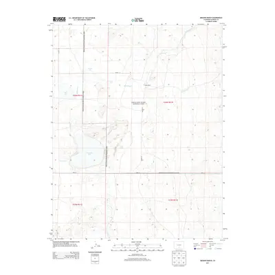
2013 Map of Medano Ranch
USGS Topo · Published 2013About this map
Great Sand Dunes National Park serves as the dominant backdrop for this high-altitude landscape in Alamosa County. The area is defined by its complex hydrologic network, where numerous water bodies such as Dollar Lake, Cotton Lake, and the larger San Luis Lake collect within a system of seasonal and perennial drainages. Flowing across the terrain are several significant waterways including Big Spring Cr, Arena Cr, and Sand Cr, which support the namesake Medano Ranch. The map reveals a delicate balance of water and sand, with the western boundary of the dunes meeting the valley floor. Transportation is limited to a sparse grid of rural routes like Medano Rd and Lane 6 N, reflecting the preservation-oriented and ranching character of the land. This detailed study captures the interaction between the creek systems and the encroaching dunes before the shifting sands further alter the local hydrology.
Find a feature on this map
19 named features on this map. Tap any name to fly to it.
Don’t see what you’re looking for? This feature index may not catch every label — zoom into the map to look around manually.
Map Details
Editions of this 2013 Medano Ranch Map
This is the sole edition of this map. No revisions or reprints were ever made.
Other maps of this area

1954 · Trinidad
USGS Topo · 1:250,000

1955 · Trinidad
USGS Topo · 1:250,000

1958 · Trinidad
USGS Topo · 1:250,000

1959 · Trinidad
USGS Topo · 1:250,000

1965 · Medano Ranch
USGS Topo · 1:24,000

1965 · Zapata Ranch
USGS Topo · 1:24,000

1965 · Dry Lakes
USGS Topo · 1:24,000

1965 · Twin Peaks
USGS Topo · 1:24,000
1966 · Hooper SE
USGS Topo · 1:24,000
1967 · Liberty
USGS Topo · 1:24,000