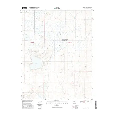
2016 Map of Medano Ranch
USGS Topo · Published 2016About this map
Medano Ranch sits at the heart of this high-desert basin, where a complex network of seasonal creeks and shallow lakes defines the San Luis Valley landscape. The western fringes of Great Sand Dunes National Park reach into this area, illustrating the meeting point of massive aeolian deposits and the hydrologic drainage of the Sangre de Cristo foothills. Prominent water features like San Luis Lake, Cotton Lake, and the smaller Dollar Lake reveal a land dominated by intermittent flows, including Big Spring Cr and San Luis Cr. This 2016 survey documents the modern layout of rural infrastructure, tracing local roads such as LN 6 N and Fifth Ave that cut across the section lines of the public land survey system. The map serves as a detailed record of water distribution and land management within this unique Colorado ecosystem.
Find a feature on this map
21 named features on this map. Tap any name to fly to it.
Don’t see what you’re looking for? This feature index may not catch every label — zoom into the map to look around manually.
Map Details
Editions of this 2016 Medano Ranch Map
This is the sole edition of this map. No revisions or reprints were ever made.
Other maps of this area

1954 · Trinidad
USGS Topo · 1:250,000

1955 · Trinidad
USGS Topo · 1:250,000

1958 · Trinidad
USGS Topo · 1:250,000

1959 · Trinidad
USGS Topo · 1:250,000

1965 · Medano Ranch
USGS Topo · 1:24,000

1965 · Zapata Ranch
USGS Topo · 1:24,000

1965 · Dry Lakes
USGS Topo · 1:24,000

1965 · Twin Peaks
USGS Topo · 1:24,000
1966 · Hooper SE
USGS Topo · 1:24,000
1967 · Liberty
USGS Topo · 1:24,000