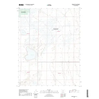
2019 Map of Medano Ranch
USGS Topo · Published 2019About this map
Medano Ranch is situated at a critical hydraulic and ecological intersection in Alamosa County, where the desert-like sands meet a complex system of artesian water. This 2019 survey captures the delicate hydrology of the San Luis Valley, showing how San Luis Cr and Big Spring Cr feed a network of wetlands and seasonal basins including San Luis Lake, Cotton Lake, and Dollar Lake. The landscape is largely defined by conservation boundaries, split between the Great Sand Dunes National Park to the east and the Baca National Wildlife Refuge in the northwest. The terrain reveals the movement of water across the valley floor through features like Arena Cr and Little Spring Cr, illustrating the transition from the high dunes to the low-lying lake beds and ranchlands that have historically supported the region's cattle and wildlife.
Find a feature on this map
21 named features on this map. Tap any name to fly to it.
Don’t see what you’re looking for? This feature index may not catch every label — zoom into the map to look around manually.
Map Details
Editions of this 2019 Medano Ranch Map
This is the sole edition of this map. No revisions or reprints were ever made.
Other maps of this area

1954 · Trinidad
USGS Topo · 1:250,000

1955 · Trinidad
USGS Topo · 1:250,000

1958 · Trinidad
USGS Topo · 1:250,000

1959 · Trinidad
USGS Topo · 1:250,000

1965 · Medano Ranch
USGS Topo · 1:24,000

1965 · Zapata Ranch
USGS Topo · 1:24,000

1965 · Dry Lakes
USGS Topo · 1:24,000

1965 · Twin Peaks
USGS Topo · 1:24,000
1966 · Hooper SE
USGS Topo · 1:24,000
1967 · Liberty
USGS Topo · 1:24,000