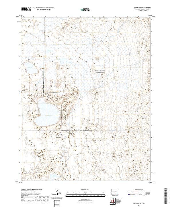
2022 Map of Medano Ranch
USGS Topo · Published 2022About this map
Great Sand Dunes National Park and the Baca National Wildlife Refuge dominate this high-desert landscape in Alamosa County. The map details a complex hydrological network where seasonal and permanent waters like San Luis Lake and Head Lake collect in the basin. These waters are fed by a series of intermittent streams descending from the dunes, including Big Spring Cr, Little Spring Cr, and Arena Cr. The drainage patterns here are distinctive, as many streams terminate or pool in the sandy terrain rather than reaching a major river system. Local access is marked by the San Luis Lakes Swa Trl and a grid of rural lanes like Guffey Ln and Fifth Ave, illustrating the intersection of protected federal lands and localized agricultural or residential footprints in the San Luis Valley.
Find a feature on this map
22 named features on this map. Tap any name to fly to it.
Don’t see what you’re looking for? This feature index may not catch every label — zoom into the map to look around manually.
Map Details
Editions of this 2022 Medano Ranch Map
This is the sole edition of this map. No revisions or reprints were ever made.
Other maps of this area

1954 · Trinidad
USGS Topo · 1:250,000

1955 · Trinidad
USGS Topo · 1:250,000

1958 · Trinidad
USGS Topo · 1:250,000

1959 · Trinidad
USGS Topo · 1:250,000

1965 · Medano Ranch
USGS Topo · 1:24,000

1965 · Zapata Ranch
USGS Topo · 1:24,000

1965 · Dry Lakes
USGS Topo · 1:24,000

1965 · Twin Peaks
USGS Topo · 1:24,000
1966 · Hooper SE
USGS Topo · 1:24,000
1967 · Liberty
USGS Topo · 1:24,000