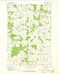
1969 Map of Medford SW
USGS Topo · Published 1971About this map
Black River and its numerous tributaries, including Pine Creek and Trappers Creek, define the rural character of this Central Wisconsin landscape during the late 1960s. The area is divided into several civil townships, including Holway, Little Black, and Hammel, where a distinct pattern of small-scale agriculture and local community hubs prevails. This geography is particularly notable for its concentration of rural educational and religious sites, such as Hillside Sch, Green Meadow Sch, and Golden Willows Sch, which served the outlying farmsteads between the river valleys.
Find a feature on this map
20 named features on this map. Tap any name to fly to it.
Don’t see what you’re looking for? This feature index may not catch every label — zoom into the map to look around manually.
Map Details
Editions of this 1969 Medford SW Map
This is the sole edition of this map. No revisions or reprints were ever made.
Other maps of this area

1951 · Lublin
USGS Topo · 1:48,000

1951 · Medford
USGS Topo · 1:48,000

1953 · Abbotsford
USGS Topo · 1:48,000

1953 · Owen
USGS Topo · 1:48,000

1953 · Eau Claire
USGS Topo · 1:250,000

1953 · Rice Lake
USGS Topo · 1:250,000

1958 · Eau Claire
USGS Topo · 1:250,000

1959 · Rice Lake
USGS Topo · 1:250,000

1963 · Abbotsford
USGS Topo · 1:62,500

1963 · Owen
USGS Topo · 1:62,500