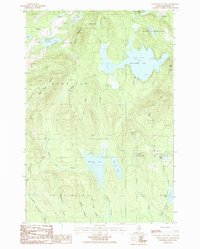
1986 Map of Meduxnekeag Lake
USGS Topo · Published 1986About this map
Meduxnekeag Lake and a series of smaller glacial ponds and streams dominate this mid-1980s terrain in Aroostook County, Maine. The landscape is defined by the Oakfield Hills, where ridges like Hunt Ridge and Bates Ridge rise between the township lines of Smyrna, New Limerick, Linneus, and T 4 R 3 Wels. Small settlements and landmarks like Timoney and Bennett are connected by a network of local roads and unimproved trails that cut through the heavily wooded surroundings.
Find a feature on this map
42 named features on this map. Tap any name to fly to it.
Don’t see what you’re looking for? This feature index may not catch every label — zoom into the map to look around manually.
Map Details
Editions of this 1986 Meduxnekeag Lake Map
This is the sole edition of this map. No revisions or reprints were ever made.
Other maps of this area

1937 · Smyrna Mills
USGS Topo · 1:62,500

1938 · Houlton
USGS Topo · 1:62,500

1940 · Amity
USGS Topo · 1:62,500

1941 · Amity
USGS Topo · 1:62,500

1941 · Mattawamkeag Lake
USGS Topo · 1:62,500

1943 · Amity
USGS Topo · 1:62,500

1943 · Mattawamkeag Lake
USGS Topo · 1:62,500

1951 · Houlton
USGS Topo · 1:62,500

1954 · Presque Isle
USGS Topo · 1:250,000

1954 · Millinocket
USGS Topo · 1:250,000