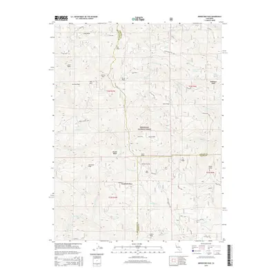
2015 Map of Mendocino Pass
USGS Topo · Published 2015About this map
Anthony Peak and Anthony Ridge dominate the high-altitude terrain where Mendocino, Tehama, and Glenn counties converge. This 2015 study of the Mendocino National Forest shows a landscape defined by sharp elevation changes, from the heights of Uhl Peak down to the Black Butte River. The road network is sparse, consisting primarily of the Paskenta-Mendocino Pass road and Forest Highway Seven, reflecting the territory's use for forestry and remote homesteading. Several family-named landmarks suggest the history of mountain ranching or seasonal habitation in this part of the Coast Range, specifically Hardy Place, Bredehoft Place, and Bollinger Place. Water sources are vital markers in this terrain, including named points like Seven Troughs Spring, Lightning Spring, and Sugar Spring. The map traces the natural drainage patterns of Grindstone Cr and Blue Slide Cr through a complex series of ridges including Cattle Ridge Point and Board Ridge.
Find a feature on this map
63 named features on this map. Tap any name to fly to it.
Don’t see what you’re looking for? This feature index may not catch every label — zoom into the map to look around manually.
Map Details
Editions of this 2015 Mendocino Pass Map
This is the sole edition of this map. No revisions or reprints were ever made.
Other maps of this area

1926 · Covelo
USGS Topo · 1:62,500

1929 · Eden Valley
USGS Topo · 1:62,500

1952 · Hull Mountain
USGS Topo · 1:62,500

1952 · Eden Valley
USGS Topo · 1:62,500

1952 · Covelo
USGS Topo · 1:62,500

1952 · Anthony Peak
USGS Topo · 1:62,500

1957 · Ukiah
USGS Topo · 1:250,000

1960 · Ukiah
USGS Topo · 1:250,000
1966 · Leech Lake Mountain
USGS Topo · 1:24,000

1967 · Plaskett Ridge
USGS Topo · 1:24,000