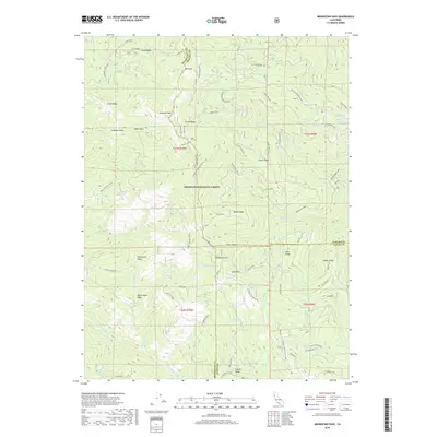
2018 Map of Mendocino Pass
USGS Topo · Published 2018About this map
Mendocino Pass serves as a critical geographic marker in this section of the Mendocino National Forest, where the boundaries of Mendocino, Tehama, and Glenn counties meet. This 2018 survey documents a landscape defined by sharp ridgelines and the headwaters of numerous creeks, including Grindstone Creek and the Black Butte River. The presence of Wells Cabin and the Grindstone Camp alongside routes like Forest Highway Seven and the Paskenta Mendocino Pass road reflects the enduring importance of mountain transit and forestry management in the California Coast Ranges. Local topography is marked by significant elevations such as Anthony Peak and Uhl Peak, providing a detailed view of the water sources that feed the regional drainage basins, including Sugar Spring and Seven Troughs Spring.
Find a feature on this map
70 named features on this map. Tap any name to fly to it.
Don’t see what you’re looking for? This feature index may not catch every label — zoom into the map to look around manually.
Map Details
Editions of this 2018 Mendocino Pass Map
This is the sole edition of this map. No revisions or reprints were ever made.
Other maps of this area

1926 · Covelo
USGS Topo · 1:62,500

1929 · Eden Valley
USGS Topo · 1:62,500

1952 · Hull Mountain
USGS Topo · 1:62,500

1952 · Eden Valley
USGS Topo · 1:62,500

1952 · Covelo
USGS Topo · 1:62,500

1952 · Anthony Peak
USGS Topo · 1:62,500

1957 · Ukiah
USGS Topo · 1:250,000

1960 · Ukiah
USGS Topo · 1:250,000
1966 · Leech Lake Mountain
USGS Topo · 1:24,000

1967 · Plaskett Ridge
USGS Topo · 1:24,000