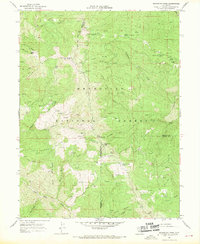
1967 Map of Mendocino Pass
USGS Topo · Published 1970About this map
Mendocino Pass serves as a critical point of crossing in this high-elevation landscape where Mendocino, Tehama, and Glenn counties converge. Surveyed in the late 1960s, the map reveals a network of remote outposts and family-named locations such as Hardy Place, Bredehoft Place, and Barras Ranch. The prominent Anthony Peak rises above the Mendocino National Forest, topped by a Lookout Tower that provided a vital vantage point for fire surveillance. The terrain is defined by steep ridges like Timber Ridge and Cattle Ridge, while water sources like Seven Troughs Spring and Rock Spring suggest the logistical necessities of high-country ranching and forest management. This document captures the transition from traditional grazing and homesteading to modern forestry infrastructure, including the Low Gap Station and the established campgrounds at Government Flat.
Find a feature on this map
58 named features on this map. Tap any name to fly to it.
Don’t see what you’re looking for? This feature index may not catch every label — zoom into the map to look around manually.
Map Details
Editions of this 1967 Mendocino Pass Map
2 editions found
Other maps of this area

1926 · Covelo
USGS Topo · 1:62,500

1929 · Eden Valley
USGS Topo · 1:62,500

1952 · Hull Mountain
USGS Topo · 1:62,500

1952 · Eden Valley
USGS Topo · 1:62,500

1952 · Covelo
USGS Topo · 1:62,500

1952 · Anthony Peak
USGS Topo · 1:62,500

1957 · Ukiah
USGS Topo · 1:250,000

1960 · Ukiah
USGS Topo · 1:250,000
1966 · Leech Lake Mountain
USGS Topo · 1:24,000

1967 · Plaskett Ridge
USGS Topo · 1:24,000