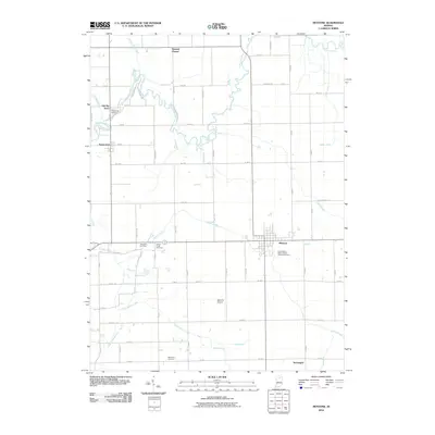
2010 Map of Mentone
USGS Topo · Published 2010About this map
Tippecanoe River meanders through this portion of Marshall and Kosciusko counties, anchoring a landscape defined by its agricultural heritage and early settlement history. The village of Mentone serves as the local hub, while the presence of Old Tip Town and the crossroads at Sevastopol reflect the area's rural development patterns. Genealogists will find considerable value in the documentation of several local burial grounds, including the Independent Order of Odd Fellows Cemetery, Yellow Creek Cemetery, and Sycamore Cemetery. The terrain is significantly shaped by a network of drainage systems such as Little Yellow Creek, Moore Ditch, and Clarence Baker Ditch, illustrating the mid-century transformation of the northern Indiana wetlands into productive farmland. From the Summit Chapel in the north to the Mentone Airport further south, the map details the transition from traditional river-bound settlements to a grid of modern county roads.
Find a feature on this map
50 named features on this map. Tap any name to fly to it.
Don’t see what you’re looking for? This feature index may not catch every label — zoom into the map to look around manually.
Map Details
Editions of this 2010 Mentone Map
This is the sole edition of this map. No revisions or reprints were ever made.
Other maps of this area

1953 · Fort Wayne
USGS Topo · 1:250,000

1953 · Chicago
USGS Topo · 1:250,000

1956 · Fort Wayne
USGS Topo · 1:250,000

1957 · Chicago
USGS Topo · 1:250,000

1957 · Inwood
USGS Topo · 1:24,000

1958 · Bourbon
USGS Topo · 1:24,000

1959 · Atwood
USGS Topo · 1:24,000

1959 · Mentone
USGS Topo · 1:24,000

1961 · Silver Lake
USGS Topo · 1:24,000
1961 · Burket
USGS Topo · 1:24,000