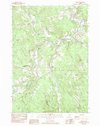
1982 Map of Mercer
USGS Topo · Published 1983About this map
The Sandy River winds through the heart of this Maine landscape, creating a series of river islands including Bowden Island, Farrand Island, and Greenleaf Island. At the dawn of the 1980s, the rural character of Somerset and Franklin counties is defined by small crossroads settlements like Mercer and Starks, connected by winding routes like River Road. The map reveals a deeply rooted local history through its numerous small burial grounds, such as Locke Cem and Frederic Cem, often found near old farmstead sites and stream junctions. Small-scale aviation and industry are present at the Beech Hill Airport and various Gravel Pits, while the drainage of Bog Stream and Lemon Stream highlights the complex hydrology of the region's low-lying valleys and wooded hillsides.
Find a feature on this map
37 named features on this map. Tap any name to fly to it.
Don’t see what you’re looking for? This feature index may not catch every label — zoom into the map to look around manually.
Map Details
Editions of this 1982 Mercer Map
This is the sole edition of this map. No revisions or reprints were ever made.
Other maps of this area

1894 · Norridgewock
USGS Topo · 1:62,500

1898 · Norridgewock
USGS Topo · 1:62,500

1904 · Anson
USGS Topo · 1:62,500

1924 · Farmington
USGS Topo · 1:62,500

1930 · Kingfield
USGS Topo · 1:48,000

1932 · Kingfield
USGS Topo · 1:62,500

1943 · Norridgewock
USGS Topo · 1:62,500

1948 · Bangor
USGS Topo · 1:250,000

1950 · Lewiston
USGS Topo · 1:250,000

1955 · Anson
USGS Topo · 1:62,500