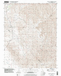
2000 Map of Mercey Hot Springs
USGS Topo · Published 2002About this map
Mercey Hot Springs sits at the intersection of arid canyonlands and agricultural history along the border of Fresno and San Benito counties. The landscape is defined by the corrugated ridges of the Panoche Hills and Panoche Ridge, where the hydrology is dominated by ephemeral flows like Little Panoche Creek and its South Fork. The presence of a Spring (Hot) and a nearby Landing Strip suggests a remote destination for travelers and health-seekers, even as more industrial features like a Radio Facility and scattered Mine sites occupy the higher elevations of Panoche Mtn. This area reflects a sparse, resource-driven settlement pattern where deep canyons like Capita Canyon and high points like the Panoche Valley floor dictated the path of rugged 4WD tracks and limited access roads.
Find a feature on this map
22 named features on this map. Tap any name to fly to it.
Don’t see what you’re looking for? This feature index may not catch every label — zoom into the map to look around manually.
Map Details
Editions of this 2000 Mercey Hot Springs Map
This is the sole edition of this map. No revisions or reprints were ever made.
Other maps of this area

1913 · Panoche
USGS Topo · 1:125,000

1921 · Laguna Seca Ranch
USGS Topo · 1:31,680

1921 · Tierra Loma School
USGS Topo · 1:31,680

1923 · Laguna Seca Ranch
USGS Topo · 1:31,680

1923 · Tierra Loma School
USGS Topo · 1:31,680

1923 · Little Panoche
USGS Topo · 1:31,680

1943 · Ortigalita Peak
USGS Topo · 1:62,500

1944 · Panoche Valley
USGS Topo · 1:62,500

1948 · Santa Cruz
USGS Topo · 1:250,000

1955 · Santa Cruz
USGS Topo · 1:250,000