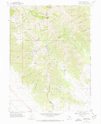
1968 Map of Mercur
USGS Topo · Published 1970About this map
Mining operations and remnant industrial structures dominate the rugged high-elevation terrain of the Oquirrh Mountains on the border of Tooele and Utah counties. In the late 1960s, the landscape around the settlement of Mercur was defined by intensive extraction, featuring the Geyser Marion Mine, Golden Gate Mine, and Sacramento Mine. Extensive Tailings and various Ruins indicate a significant history of processing ores in this district. Further south, the map identifies the Sunshine (Site) and Manning (Site), appearing as historical footprints within the mountain canyons. Transport networks are marked by an Old Railroad Grade winding through the southeastern valleys toward the Rush Valley, while a Military Reservation Bdy bisects the central peaks near Lewiston Peak.
Find a feature on this map
47 named features on this map. Tap any name to fly to it.
Don’t see what you’re looking for? This feature index may not catch every label — zoom into the map to look around manually.
Map Details
Editions of this 1968 Mercur Map
2 editions found
Other maps of this area

1885 · Tooele Valley
USGS Topo · 1:250,000

1915 · Fairfield
USGS Topo · 1:62,500

1917 · Fairfield
USGS Topo · 1:62,500

1918 · Stockton
USGS Topo · 1:62,500

1947 · Fivemile Pass
USGS Topo · 1:62,500

1947 · Goshen Pass
USGS Topo · 1:24,000

1949 · Fivemile Pass
USGS Topo · 1:24,000

1949 · Goshen Pass
USGS Topo · 1:24,000

1953 · Tooele
USGS Topo · 1:250,000
1954 · Tickville Spring
USGS Topo · 1:24,000