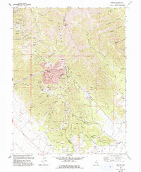
1993 Map of Mercur
USGS Topo · Published 1993About this map
The Oquirrh Mountains of Utah reveal a landscape dominated by industrial mineral extraction and the remains of boom-era mining camps. This map centers on the Mercur (Site), highlighting a massive Open Pit Mine and extensive Tailings Pond systems that define the modern geography of Mercur Canyon. The proximity of former settlements like Manning (Site) and Sunshine (Site) illustrates the high density of historical activity along the canyon floors and slopes. The map also traces the infrastructure required for these operations, including a Railroad Grade and numerous specialized sites like the Violet Ray Mine and Chloride Point Mine. Rising above these excavations are natural landmarks such as Lewiston Peak and Eagle Hill, providing a stark contrast between the undisturbed peaks and the heavily modified valleys below.
Find a feature on this map
53 named features on this map. Tap any name to fly to it.
Don’t see what you’re looking for? This feature index may not catch every label — zoom into the map to look around manually.
Map Details
Editions of this 1993 Mercur Map
This is the sole edition of this map. No revisions or reprints were ever made.
Other maps of this area

1885 · Tooele Valley
USGS Topo · 1:250,000

1915 · Fairfield
USGS Topo · 1:62,500

1917 · Fairfield
USGS Topo · 1:62,500

1918 · Stockton
USGS Topo · 1:62,500

1947 · Fivemile Pass
USGS Topo · 1:62,500

1947 · Goshen Pass
USGS Topo · 1:24,000

1949 · Fivemile Pass
USGS Topo · 1:24,000

1949 · Goshen Pass
USGS Topo · 1:24,000

1953 · Tooele
USGS Topo · 1:250,000
1954 · Tickville Spring
USGS Topo · 1:24,000