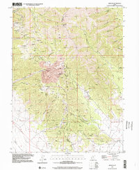
1997 Map of Mercur
USGS Topo · Published 2002About this map
The Oquirrh Mountains define this industrial landscape, where the legacy of late 19th-century mining is etched into the terrain of Tooele and Utah counties. The map identifies several historical settlement locations, including the Mercur (Site), Manning (Site), and Sunshine (Site), which were once thriving gold and silver camps. A massive Open Pit Mine dominates the central canyon, a stark contrast to the smaller historic workings like the Chloride Point Mine and numerous prospects scattered across Silveropolis Hill and Lion Hill.
Find a feature on this map
47 named features on this map. Tap any name to fly to it.
Don’t see what you’re looking for? This feature index may not catch every label — zoom into the map to look around manually.
Map Details
Editions of this 1997 Mercur Map
This is the sole edition of this map. No revisions or reprints were ever made.
Other maps of this area

1885 · Tooele Valley
USGS Topo · 1:250,000

1915 · Fairfield
USGS Topo · 1:62,500

1917 · Fairfield
USGS Topo · 1:62,500

1918 · Stockton
USGS Topo · 1:62,500

1947 · Fivemile Pass
USGS Topo · 1:62,500

1947 · Goshen Pass
USGS Topo · 1:24,000

1949 · Fivemile Pass
USGS Topo · 1:24,000

1949 · Goshen Pass
USGS Topo · 1:24,000

1953 · Tooele
USGS Topo · 1:250,000
1954 · Tickville Spring
USGS Topo · 1:24,000