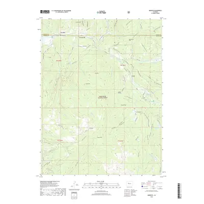
2019 Map of Meredith
USGS Topo · Published 2019About this map
The Fryingpan River flows through the northern reaches of this Colorado high-country landscape, passing through the small settlements of Meredith and Thomasville. Located within the White River National Forest, the region is defined by a network of gulches and ridges that feed into the river system. The presence of the Hunter Tunnel in the southeastern quadrant, alongside the Sawyer Cr Conduit, indicates a managed water system designed to navigate the complex elevations between peaks like Mt Yeckel and Cyclone Mtn. Historical land use is visible in areas such as Lamont Pasture and Sawmill Park, while the Norrie Powerline tracks through the center of the sheet toward the community of Norrie. Water resources are central to the geography here, from high-altitude features like Sawyer Lake and Chapman Lake to the Himmelland Reservoir near the Eagle and Pitkin County line.
Find a feature on this map
66 named features on this map. Tap any name to fly to it.
Don’t see what you’re looking for? This feature index may not catch every label — zoom into the map to look around manually.
Map Details
Editions of this 2019 Meredith Map
This is the sole edition of this map. No revisions or reprints were ever made.
Other maps of this area

1893 · Aspen
USGS Topo · 1:62,500

1895 · Aspen
USGS Topo · 1:62,500

1909 · Mount Jackson
USGS Topo · 1:125,000

1911 · Mount Jackson
USGS Topo · 1:125,000

1957 · Leadville
USGS Topo · 1:250,000

1959 · Leadville
USGS Topo · 1:250,000

1960 · Leadville
USGS Topo · 1:250,000
1960 · Thimble Rock
USGS Topo · 1:24,000

1960 · Aspen
USGS Topo · 1:24,000
1960 · Mount Champion
USGS Topo · 1:24,000