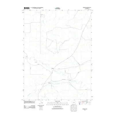
2012 Map of Meriden
USGS Topo · Published 2012About this map
The high plains of Laramie County are defined here by a network of ranching homesteads and an intricate irrigation system. The small settlement of Meriden serves as a central point along the winding course of Horse Cr, where the landscape is dotted with established family-named holdings such as Morrie Ranch, Brown Ranch, and Petsch Ranch. This 2012 survey illustrates the vital role of water management in the region, tracing the paths of the Springvale Number 1 Ditch, Little Horse Creek Number 4 Ditch, and the Wood and Lykins Ditch. These man-made channels diverge from natural waterways like Little Horse Cr and Herrick Cr to support the agricultural demands of the Wyoming range. Notably, the map also identifies the Sprinkler Geyser, a distinct hydrological feature located south of the main Meriden settlement, highlighting the unique geological character of this prairie environment.
Find a feature on this map
25 named features on this map. Tap any name to fly to it.
Don’t see what you’re looking for? This feature index may not catch every label — zoom into the map to look around manually.
Map Details
Editions of this 2012 Meriden Map
This is the sole edition of this map. No revisions or reprints were ever made.
Other maps of this area

1899 · Goshen Hole
USGS Topo · 1:125,000

1954 · Cheyenne
USGS Topo · 1:250,000

1958 · Cheyenne
USGS Topo · 1:250,000

1960 · Diamond Flat
USGS Topo · 1:24,000

1960 · Petsch Reservoir
USGS Topo · 1:24,000

1960 · Rocky Hollow
USGS Topo · 1:24,000

1960 · Kessler Gap
USGS Topo · 1:24,000

1960 · Meriden
USGS Topo · 1:24,000

1960 · La Grange
USGS Topo · 1:24,000

1963 · Midway
USGS Topo · 1:24,000