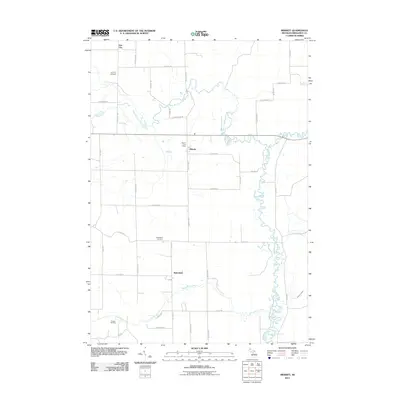
2011 Map of Merritt
USGS Topo · Published 2011About this map
The Muskegon River meanders southward through this rural section of Missaukee County, defining a landscape shaped by both natural waterways and late 20th-century energy extraction. The small settlement of Merritt serves as a central point, anchored by the Merritt Post Office and a grid of rural roads like N Merritt Rd. To the south, Butterfield sits near the banks of Butterfield Creek, while Star City occupies the northwestern corner. Genealogists will find the Star City Cemetery and Butterfield Cemetery clearly marked, offering precise locations for family history research. This 2011 survey also captures the industrial presence of the Prosper Oil Field in the southwest, illustrating the ongoing significance of petroleum resources alongside traditional agricultural plots. The inclusion of the Nellieville Ditch indicates a managed approach to the area's hydrology, balancing the wild path of the river with local land needs.
Find a feature on this map
40 named features on this map. Tap any name to fly to it.
Don’t see what you’re looking for? This feature index may not catch every label — zoom into the map to look around manually.
Map Details
Editions of this 2011 Merritt Map
This is the sole edition of this map. No revisions or reprints were ever made.
Other maps of this area

1954 · Traverse City
USGS Topo · 1:250,000

1956 · Houghton Lake
USGS Topo · 1:62,500

1956 · Lake City
USGS Topo · 1:62,500

1957 · Harrison
USGS Topo · 1:62,500

1957 · Marion
USGS Topo · 1:62,500

1958 · Traverse City
USGS Topo · 1:250,000

1983 · Cadillac
USGS Topo · 1:100,000
1983 · Meads Landing
USGS Topo · 1:25,000

1983 · Moddersville
USGS Topo · 1:25,000

1983 · Stittsville
USGS Topo · 1:24,000