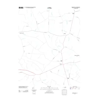
2013 Map of Merry Hill
USGS Topo · Published 2013About this map
Merry Hill and the surrounding coastal plain of Bertie County are defined by an intricate network of wetlands and low-lying watercourses. This landscape is crisscrossed by several substantial swamplands, including Cricket Swamp, Eastmost Swamp, and the interestingly named Bloody Fork. The settlement pattern is characterized by numerous historic crossroads and small communities that have long served the local agricultural economy. These include Taylors Store, Ashland, and Todds Crossroads, which are connected by a web of local roads such as Bethany Church Rd and Capeheart Church Rd. In the northeast, Mount Gould sits near the headwaters of the regional drainage system, while Salmon Cr and Wading Place Cr drain the southern reaches. The presence of these named water bodies and traditional road junctions reflects a long-standing rural infrastructure adapted to the region's unique hydrology.
Find a feature on this map
46 named features on this map. Tap any name to fly to it.
Don’t see what you’re looking for? This feature index may not catch every label — zoom into the map to look around manually.
Map Details
Editions of this 2013 Merry Hill Map
This is the sole edition of this map. No revisions or reprints were ever made.
Other maps of this area

1904 · Edenton
USGS Topo · 1:62,500

1942 · Edenton
USGS Topo · 1:62,500

1943 · Plymouth
USGS Topo · 1:125,000

1943 · Edenton
USGS Topo · 1:62,500

1953 · Norfolk
USGS Topo · 1:250,000

1953 · Rocky Mount
USGS Topo · 1:250,000

1954 · Rocky Mount
USGS Topo · 1:250,000

1954 · Westover
USGS Topo · 1:24,000

1978 · Windsor South
USGS Topo · 1:24,000
1979 · Woodard
USGS Topo · 1:24,000