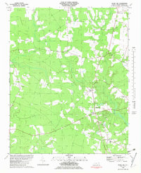
1982 Map of Merry Hill
USGS Topo · Published 1982About this map
The settlement of Merry Hill serves as the focal point for this coastal plain landscape in Bertie County during the late 1970s and early 1980s. Defined by a network of dense wetlands and drainage systems, the area features Flat Swamp Creek and Cricket Swamp winding through heavily wooded terrain. Local life is anchored by institutional landmarks such as Lawrence Academy and several rural congregations, including Riverside Ch near the northern boundary and Capeharts Ch situated centrally between small crossroads.
Find a feature on this map
18 named features on this map. Tap any name to fly to it.
Don’t see what you’re looking for? This feature index may not catch every label — zoom into the map to look around manually.
Map Details
Editions of this 1982 Merry Hill Map
This is the sole edition of this map. No revisions or reprints were ever made.
Other maps of this area

1904 · Edenton
USGS Topo · 1:62,500

1942 · Edenton
USGS Topo · 1:62,500

1943 · Plymouth
USGS Topo · 1:125,000

1943 · Edenton
USGS Topo · 1:62,500

1953 · Norfolk
USGS Topo · 1:250,000

1953 · Rocky Mount
USGS Topo · 1:250,000

1954 · Rocky Mount
USGS Topo · 1:250,000

1954 · Westover
USGS Topo · 1:24,000

1978 · Windsor South
USGS Topo · 1:24,000
1979 · Woodard
USGS Topo · 1:24,000